
For a person with New Urbanist (or Old Urbanist) leanings, a visit to Seaside feels a bit like a pilgrimage to a sacred site. Although the merits of the town have been debated for years, its significance in the history of American urban planning is undeniable. As one of the earliest steps in the evolution of the New Urbanism, which wouldn't formally arrive until more than a decade after the town's 1981 founding, Seaside is an intriguing glimpse into the origins of the movement. For me, it was a chance to examine the planning decisions made at this early juncture, including those that were repeated in later New Urbanist developments, and those which, for various reasons, largely fizzled out.
First, though, the intentions of the designers, in their own words:
"Seaside is widely acclaimed, financially successful, and almost completely built-out. It has become a symbol of the New Urbanism, exemplifying the movement’s underlying principles, which can be applied to all urban conditions: the built environment must be diverse in use and population; it must be scaled for the pedestrian yet capable of accommodating the automobile and mass transit; and it must have a well defined public realm supported by an architecture that reflects the ecology and culture of the region."
Urbanism is distinct from architecture, however. On that count, does Seaside deliver on its promise of an environment "scaled for the pedestrian yet capable of accommodating the automobile"? Let's look at a typical Seaside street:

Interestingly, Seaside for the most part has no rear alleys. This New Urbanist calling card is present only in the newest areas of the town. On the above street, parking spaces are tastefully integrated alongside the single family homes – a far more economical solution than rear parking garages, but one which is undermined by the addition of the two additional parking lanes along the brick roadway. Do vacation homes really need three parking spaces each? This in excess of most municipal standards for single-family homes, which generally require no more than two spaces.
In the area along the beach south of Highway 30A, however, a handful of really narrow streets do appear, and these are some of the most beautiful and memorable parts of the town.

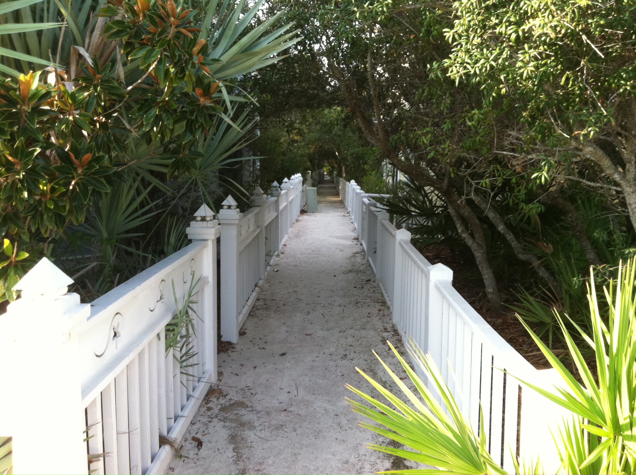
These paths, apparently introduced at the suggestion of Léon Krier (whose Classicist architectural fingerprints are evident everywhere you look), run in between rear property lines in most blocks. The scale is delightfully


[8/17 update: After returning to Seaside at 9:00 p.m., I'm more confident about my earlier observations of the area. At that time of day, activity is heavily concentrated around the beach-side restaurant and retail area. In recognition of this, the town has introduced numerous mini-trailer eating establishments (presumably seasonal) along the southern perimeter of the amphitheater, facing across 30A toward the small-scale shops and eateries on the other side of the road. Even at midday they are running a steady business (see below):]

The exception is a beautiful square framed by Seaside's handful of townhouses -- the feel is part Charleston, part French Quarter:

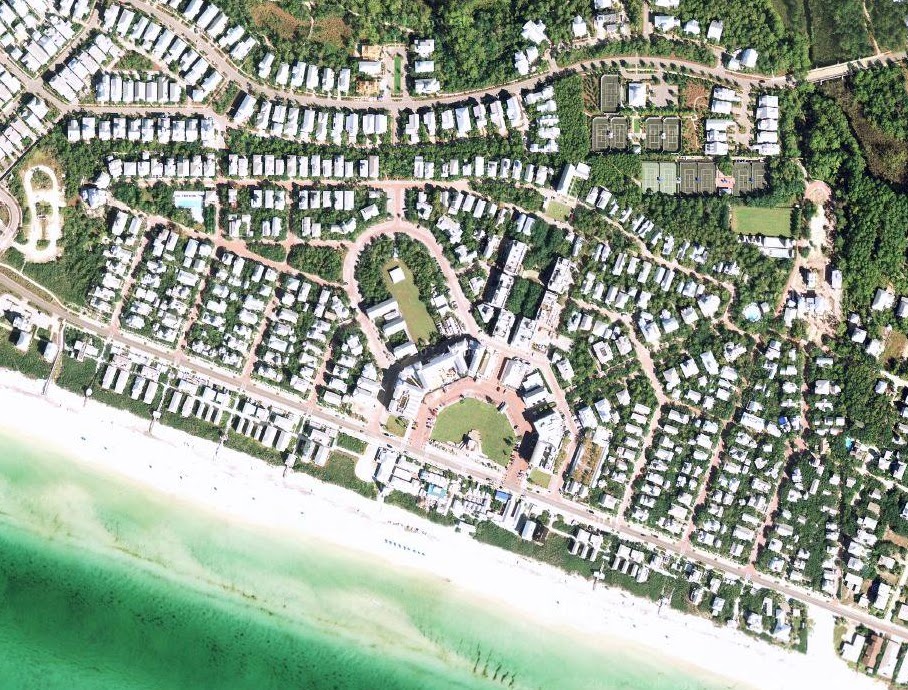
"First off, there is a humane environment, pleasant, avoiding many of the mishaps and ugliness of modern American development. It has charm. It has some atmosphere. ... In order to achieve this very large, and humane effect [at Seaside], Andrés [Duany] has used what is a partly mechanical method. He has therefore been forced, in this first round of experiments ... to make a somewhat mechanical version of the ideal.The street layout at Seaside melds together a concentric ringed pattern with a typical 19th century grid of blocks generally 200' wide and 400' long. The influence of John Nolen, and in particular his plan for Venice, is evident. Yet, unlike in Nolen's plan, the individual street segments are resolutely straight, refusing to bend or meander (with a handful of exceptions). The block lengths, too, are of predictable dimensions. I think this is the "subtle mechanical character" which Alexander is referring to.
It is the nature of this 'mechanical' aspect which has to be examined carefully.
In essence it consists of making a rigid framework, and allowing, then considerable individual variation within it. But the carcase, the street grid, is rigid: it does not arise from the give and take of real events. In this regard it is unlike an organic community. It is as if one were to have a rigid mechanical skeleton and hang variational flesh on it. That is not the same as making a coherent whole, in which the public space arises organically from detailed, and subtle adaptations to terrain, human idiosyncracy, individual trees, accidental paths, and so on. ...
The subtle mechanical character which underlies the production of the street grid, is visible, though, in a more disturbing quality. Occasionally one hears that there is something 'unreal' about Seaside. Some of it is carping. Perhaps jealousy. But there is something about this comment that is real, and which goes to the very root of our current inability to make living space in towns."
A perfectly straight street, after all, tells us no more than: "A planner drew me with a T-square, and a surveyor marked me out." We intuitively sense this, since the march of human feet over ground will almost never proceed in a perfectly straight line. Is it more efficient than a street which emerges from "detailed and subtle adaptations to terrain"? Not necessarily – it may be less responsive to topography and may require more grading, as was the case with the grids of New York or San Francisco. The perfectly straight street itself is a mechanical, or utilitarian aesthetic (to borrow Nathan Lewis' terminology), the aesthetic of the professional surveyor whose instruments are designed to mark straight lines and right angles, whether with the ancient groma or the modern laser theodolite.
The grid appears a preferred alternative to the modern suburban streets which meander purely for aesthetic effect, as did the early suburban plans such as Riverside, and in a true utilitarian sense that is probably correct, as the grid provides better connectivity and is easier to navigate. But in comparison to an organic plan, especially in a town of small size, the advantages as against the process Alexander describes may be less clear.
In terms of density, Seaside's use of single-family homes on small lots with modest setbacks and small backyards (and with very few grass lawns in evidence) is a separate achievement in and of itself. Although the houses are large and gracious, densities of about 6 units/acre are achieved. Backyards are considerably smaller than in the typical 19th century streetcar suburb. Overall, Seaside's density, in high season, appears to rise to as high as 12-14,000 people per square mile. This seems to be only slightly less than at Kentlands, despite Kentlands' much greater use of attached housing, perhaps due in part to the presence of space-devouring alleys in the Maryland development.
Overall, despite the critiques I've included here, I found Seaside to be more impressive than I had expected. The architectural achievement alone is inspiring, and one's hat has to go off to Duany and other architects who, during a nadir in design in the late 1970s and early 1980s, recreated so much beauty in the built environment. The town continues to improve and refine itself with infill and new design ideas. The area south of 30A, meanwhile, hints at a genuine traditionalist approach to urbanism. It is not an approach that has characterized most subsequent New Urbanist developments, however.
For the next installment in this series, I'll look at Seaside's successor: Rosemary Beach.
 |
| The architecture book selection at the Seaside bookstore. |

Looking at the map, it appears that all of the narrow paths in Seaside are accessory pedestrian routes, rather than the main "street" access to the homes. The streets themselves are moderate at 40 feet with no sidewalk, though with setbacks it is 60 feet between houses in most of the area.
ReplyDeleteRather than using 4-way stop signs, narrower streets would have done a great deal to slow traffic speeds. If the streets were only 30 feet with some parked cars on each side, cars would go much slower to avoid problems passing a car coming the other way. This would make walking in the street much more pleasant. But why not go even narrower, to 20 or 16 feet, since all the houses have off-street parking?
Joseph -- that is true for all but the homes directly on the beachfront, which are accessible only by the pedestrian pathways.
ReplyDeleteAs for the stop signs, I should note that the streets immediately surrounding Seaside (on the map, Cypress Hill and Dogwood Streets) control traffic by being narrow -- much narrower than Seaside's streets -- and unpaved, which slows down cars but also impedes bikes. These streets do meander naturally, also, following the slight contours of the land.
Great site feature to explore these places. Real estate price information would be helpful (looking at construction costs compared to sale price).
ReplyDeleteHow much real community is there? Is it just a vacation spot that is built up?
"the homes directly on the beachfront, which are accessible only by the pedestrian pathways"
ReplyDeleteI'm surprised the county zoning board allowed that. Is there vehicle access and parking? Are those homes given addresses along the main highway, or along the pedestrian street?
"The streets immediately surrounding Seaside ... control traffic by being narrow ... and unpaved"
That's interesting. Do you have photos of those streets? There is no coverage of this area on Google Streetview, unfortunately.
This is an excellent description by Charles, who tells us what we need to know.
ReplyDeleteOverall, I am impressed. The result is pretty good, better than some "New Urbanist" developments of the 1990s. I would note, for example, the use of outside parking rather than any sort of garage or carport. Another biggie, for me, was the elimination of separated sidewalks. I don't know about the gravel roads though ... there's a reason people went to all the trouble to pave European streets with cobblestones. (Basically, walking in the mud is a drag.) The result is very much like I document throughout urban areas in Tokyo, although at double the width the result is that they tend to become automobile dominated. The very narrow walking pathways are promising but they are still within the context of an "alley," or some sort of accessory utility street.
Thumbs up for the architecture. The commercial areas still suffer from "Small Town America Main Street-itis," or a 19th Century Hypertrophic pattern. I much prefer an Asian pattern where the large streets, where they exist, are considered utility streets and the interesting commercial bits are on small streets. See, for example, SoHo in New York City, where the real action is on the side streets while Broadway is more of a transportation access.
All in all, this was an excellent showing for the early days of "New Urbanism." Unfortunately, rather than beginning here and moving more towards the European Village ideal, of narrower streets, fewer cars and more walking, they began here and moved towards the U.S. suburban ideal, with a few leftover aesthetic tweaks.
I am flattered that Charles makes use of my idiosyncratic terminology. Once you have names for these repetitive patterns in U.S. city design, it is so much easier to analyze.
Joseph -- I have added a photo above which shows a street of the type I was referring to. As for the houses, as far as I could tell parking is accommodated in shared garages fronting on 30A. Probably the addresses are marked 30A as well, I did not check. Nonetheless, direct access is only by public pedestrian lanes.
ReplyDeleteNathan: Thanks for the kind comment and great point about the lack of sidewalks -- I ought to have mentioned that. I wasn't necessarily advocating for unpaved streets, just noting that a smooth pavement, while it is nice for bicycles, also encourages speeding when streets are wide and straight. Seaside is evidently grappling with that problem at the moment.
Charlie,
ReplyDeleteI get the impression that the gravel was a reaction to two things: one, that at forty feet wide, you would have a lot of asphalt which is unpleasant; and two, at forty feet wide, cars are encouraged to go faster than you'd want. I see both as a reaction to a roadway which is too wide for its purpose here, and a solution which reflects the rural/urban confusion typical of the "New Urbanists" -- that to make a place more comfortable for people, you make it "more rural," i.e. less density, more setbacks, more "Green Space," gravel roads and white picket fences. I would say rather that it should be "more urban," i.e. more compact and narrower streets, a place appropriate for people walking about and not cars.
I'm looking forward to your explorations of the nearby towns.
Regarding the "paths" suggested by Leon Krier, their design is not only attractive but also utilitarian in nature. They contain the underground "wire" utilities serving Seaside's home: power, phone; & cable. I got the impression from Steven Brooke's book "Seaside" (a great reference, by the way) that their development as aesthetically pleasing "paths" was essentially a lucky outgrowth of their placement AS a utility servitude... Robert Davis was quoted in that book as saying, "..children love them"... As a planner and long-time Seaside visitor I can say that I use them often, especially as a means to access the beach from a rental cottage, rather than walking the streets.
ReplyDeleteAnd in regards to the streets, another point: As Brooke points out, Davis originally wanted the streets to be unpaved, similar to the sand/gravel streets just east of Seaside that ares shown in your new photo. This would be similar to the streets he remembered growing up with during his summers spent in Seagrove Beach. The homeowners wanted paved streets, and as an acceptable compromise, pavers were used. I can say that the brick-like paver surface and the narrower street cross section generally slows down traffic, at least moreso than if it were a concrete or asphalt street. The almost constant presence of bicyclists and families walking down the streets to the beach also serve to slow down cars. Seaside, however, is a victim of its own success: on a typical busy summer day the streets and parking spaces are filled not only with the cars of those staying or working IN Seaside, but also with as many cars (or more) of daytime /dinnertime "sightseeing" visitors to Seaside. And I would hazard that the "high-speed" drivers "coming to rolling stops" that you mentioned are likely the latter category.
Thanks for your comment, Bruce. I wasn't aware that the paths doubled as utility easements. Having not walked down many of them the first time through the town, I also missed the presence of the numerous accessory cottages behind the main houses which are given direct entrances off these paths. I may do a follow up post with a few more photos on this topic.
ReplyDeleteI do understand why the streets needed to be paved -- the gravel surface is not kind to cruiser bikes or feet protected only by flip-flops, while an all-sand surface would be quickly eroded by rain and car traffic. The paved surface is friendlier to all modes of transportation, with the only downside being that cars can now move more quickly. This is magnified by the 20-foot ROW on most residential streets (although some other streets are narrower). I wouldn't be surprised to find that most of the speeders are outside visitors, but they are responding to the cues given to them by the environment, for better or worse. Given the low volume of traffic (as opposed to the number of parked cars) it is at least debatable whether passing space for two cars is needed throughout.