Thursday, September 29, 2011

What About Houston?

In the comments to recent posts, Chris Bradford and Cambias have cited Houston as a counter-example of a city without zoning which has developed a highly centralized, high rise-dominated downtown in spite of the fact that no zoning boundaries nor any physical obstacles constrain the horizontal growth of the central business district.  So why then has a small forest of skyscrapers grown so closely together?

A few quick thoughts and observations:
  • First, Houston's downtown, contrary to appearances, isn't that dense.  The Floor Area Ratio of the 1.53 square mile downtown area, which contains numerous skyscrapers and over four million square meters of office, retail and residential space, is only about 1.07, much less than large areas of central Paris.  It seems improbable, but it's what I got with the numbers I could locate.
  • Second, what has been the effect of Houston's vast freeway network on land values in the CBD in the post-1950s era?  A map of the network resembles a giant dartboard centered on the downtown, with the inner loop drawn tightly around a very small area:
  • Consider also what the technological possibility of super-tall buildings has on land values within this targeted area.  As the blog NeoHouston observes in in a similar transit-oriented context:
"As has been widely discussed, redevelopment around transit stations has been less widespread in Houston than in other cities, and much of this is because of the work of speculators. While this issue is not unique to Houston, it is compounded by the lack of development regulations. Essentially, every speculator is pricing their land for the construction of a skyscraper, when the market may only be suited for low-rise. Redevelopment activity is significantly impaired when there is this disconnect between the realistic development potential of a property and the astronomical price expectations of speculators."
If every downtown Houston landowner prices his land for a 60-story office tower, development, one might think, would likewise be impaired.  Even if very high demand exists for office space, few developers have the resources in time or money to purchase the land and construct such a tower.  And history shows that building one can be a risky venture, as economic conditions may have changed greatly during the years from planning to completion.  In any event, whether or not this explanation has any validity, in spite of a roaring economy in the 1970s through the early 1980s, and again in the 1990s to today, much of Houston's downtown remains covered by surface parking lots.  Mid rise development, however, has flourished in the area just outside the loop (see last page).

In fact, building coverage today is far less than it was in 1912 when the below drawing was made (adapted from the excellent Big Map Blog), showing a mid-rise city punctuated by occasional tall buildings, a format which persisted for the most part into the 1950s:

So how much can Houston tell us about development patterns in the absence of zoning?  Even if it disproves the idea that a zoning-free city will tend to develop in a more horizontal pattern (not that I necessarily agree that it does), might Houston have  benefited overall from a modest height limit?  What other factors might have contributed to this pattern? 

***Note: Regarding Houston's zoning, please see Christof's comment below on Houston's downtown exemption from municipal parking requirements.  Here is a link to a map of Houston's downtown tunnel system.

Monday, September 26, 2011

Height Limits: The Forgotten Debates

Robert Fogelson's Downtown: It's Rise and Fall, 1880-1950 has a fascinating chapter devoted entirely to the early 20th century debates over height limits in American cities.  The arguments of the opposing sides as late as the 1920s bear an uncanny similarity to some of the recent back-and-forth between Ed Glaeser and Michael Mehaffy.  Although many of the arguments of those in favor of limits at the time have since been debunked (that skyscrapers were more fire-prone, for instance), the most important point of contention, by far, was based not on a difference of opinion, but on a consensus:
"On one point both sides agreed.  If a height limit [in St. Louis, a representative case] as low as 125 feet was imposed, the business district would spread out.  So much the better, argued some.  In the interest of increasing property values, a St. Louis real estate agent claimed, 'It is better to have lower buildings scattered over 15 or 20 blocks than to have a few big buildings in half a dozen blocks.' Not so, responded others.  If downtown St. Louis was spread over a wider territory, it would make it harder to do business in the city.  The more compact the business district, the better."
And in New York: "[A height limit proposed in 1908] failed for another, more baffling reason.  As the Real Estate Record pointed out, a height limit would have spread the business district 'over a much larger area,' and thus would have raised property values everywhere in Manhattan except on or near lower Broadway and Fifth Avenue, where most of the skyscrapers were erected." 
It appears that some agreement existed that a height limit would produce a net increase in citywide property values, and further that this increase would be equitably spread among a large number of property owners, a compelling point which was met by the argument that the agglomeration effects of high density, in concentration, outweighed this loss in values.  The argument of the pro-limit faction, however, necessarily depended on the absence of zoning, for with height limits imposed, the resultant economic benefits could only flow if the business district were permitted unencumbered horizontal expansion into existing non-commercial areas.

In the 1920s, however, the prevailing model of height limits with no zoning was swiftly replaced by a new model of zoning and height limits, except in the existing business core. The exception was Washington, D.C., which retained relatively low height limits while zoning itself into a corner a sure recipe for space shortages and inflated rents down the line (it also did not help that L'Enfant's city plan, with its extravagantly wide streets, left Washington with less downtown buildable area than almost any other large American city).

So which side of the debate was right?  Was there a right answer at all?  It is difficult to know, since there is no large North American city with a meaningful height limit but no zoning that can serve as a point of comparison (European examples are abundant, however).  In a sense the full urban vision of those who advocated for limits is more distant than ever, for not only has the pro-height and agglomeration viewpoint (as presented in its undiluted essence in Triumph of the City) continued to assert itself, but even the historical preservationists whom Glaeser takes to task frequently advocate against horizontal densification, as the lower-density neighborhoods encircling many a central business district frequently happen to be filled with a city's most notable architecture, or most vocal homeowners.  Still, the economic claims of the pro-limit real estate men of the 1920s should in theory be no less valid today than they were at the time, and remain available as a potential, but long-dormant, counter-argument to the economics of the agglomerationists. 

Related content:
A vigorous debate over Washington's Height Act at GGW.

Related posts:

Friday, September 23, 2011

The Zoning Paradox

At the new website The Atlantic Cities, Ryan Avent has published an adapted portion of his new book in which he makes a common sense, but infrequently raised, observation about the economic effects of zoning laws:
"People tend to have a proprietary feeling about their neighborhoods, particularly when they have large sums of money on the line thanks to their investment in their home. This feeling leaves urban property rights in a gray area. Residents are remarkably willing to dictate to private property owners what can and can't be done with their land. They're willing to approve restrictive zoning rules and lobby against permitting in ways that dramatically reduce potential land value, without ever dreaming of compensating owners and would-be developers."
If zoning reduces land values, however, how is it that zoning has been convincingly shown, by Ed Glaeser among others, that zoning contributes to inflated housing costs?  The answer, what I'm referring to as the zoning paradox, is simply stated: zoning increases the per unit cost of housing, while decreasing underlying land values.*  I've alluded to this before in an earlier post, but let me illustrate with a real life example to demonstrate this seemingly counterintuitive point.  You may be able to find an example in your own town or city that will work out in similar fashion.

Here's an image from near my old neighborhood in Nashville, the Music Row area, where what had long been a single-family residential area was rezoned decades ago for a mix of office, residential and commercial space in the area to the west of  the alley running between the two streets shown (this was in reaction to the arrival of the city's famous music recording industry into the area).  Given its mix of uses, the rezoned area does not enjoy the typical "protections" of Euclidean zoning, while the single family area is strictly limited to single-family and duplex residential.  Since protection from the externalities generated by incompatible uses is commonly mentioned as an economic benefit of zoning, this factor should, in theory, weight the scales on the side of the single-family area.

If we look at the appraised value of one of the houses on the rezoned side -- a house of similar characteristics to those in the single family area, having been built for that purpose in the 1920s -- we find a per acre land value of $1,786,000.  On the opposite side of the block, where duplex residential zoning applies, land values are only $294,000 per acre!  In fact we can go further and note that the combined value of the single family home and the land on the residential side is only half the value of the land alone on the rezoned side of the block.  The net effect, therefore, is to lower overall property values.  The property tax benefits to the city of more permissive zoning seem clear. 

It's worth noting that these values are derived from an allowance of as much as 80 units per acre on the mixed-use side (a genuinely urban density), while the duplex zoning on the residential side permits slightly less than 12 units per acre.  Yet with this greater intensity of development, per unit costs fall considerably for new construction (although the price per square foot may actually rise**).  By contrast, on the residential side, even though land values are low by comparison, a developer purchasing an existing home must build a very large and expensive house to justify a tear-down.  Since the market for very large homes is saturated by the imposition of minimum lot sizes and other low-density regulations throughout the city, however, this means that little redevelopment will occur, even though this neighborhood is only a mile and a half from the downtown.  Existing houses stagger on, while development is displaced elsewhere.

Overall, the effect of these density and use-limiting restrictions seems to be to concentrate financial benefits in the hands of incumbent homeowners (by inflating the values of homes), while impoverishing the city as a whole (by substantially devaluing the property tax base while increasing the cost of both rentals and new home purchases). 

One last point: simply because permissive zoning increases land values, does it necessarily follow that eliminating some or all density-related restrictions -- minimum lot sizes, height limits, etc. -- will provide a net economic benefit to the city?   I'd suggest Michael Lewyn's work as a good starting point on that issue, but in a follow-up post I'll venture a couple more thoughts on the topic.

Related posts: Did Zoning Ever Conserve Property Values?

*See On the effects of minimum-lot-size zoning, S. Bucovetsky.  This paper deals with minimum lot sizes only, but logically the same analysis should apply to other restrictions, such as FAR ratios and other density and use limitations.
**The higher per square foot prices paid in certain instances that I was able to identify suggest that buyers, at least in this market, are willing to give up large amounts of square footage in exchange for a reasonable price -- to the extent of taking a apartment 60% smaller than a new duplex home for a price only 30% less.  This could indicate an undersupply of mid- and small-sized apartments in this area (almost certainly true) or that the marginal value of each additional square foot above, say, 1200 sq. ft. is quite low for the type of buyers who are looking in the area.

Monday, September 19, 2011

Vancouver and the Zoning Straitjacket

Edit 9/20: Added links to Vancouver planner Larry Beasley's comments on tall buildings and DC's Height Act from last year, revealing at the very least an ambivalent attitude toward skyscrapers.

As a follow up to last Monday's post, I'd like to take a bit of a historical excursion to illustrate the effect that zoning has had on Vancouver's downtown commercial district, using that city only as a representative example of many dozens of others throughout North America.  The hypothesis that skyscrapers are a necessary adaptation to artificial constraints on commercial space depends upon a showing that space has, in fact, been delineated by legal means, rather than by market forces.

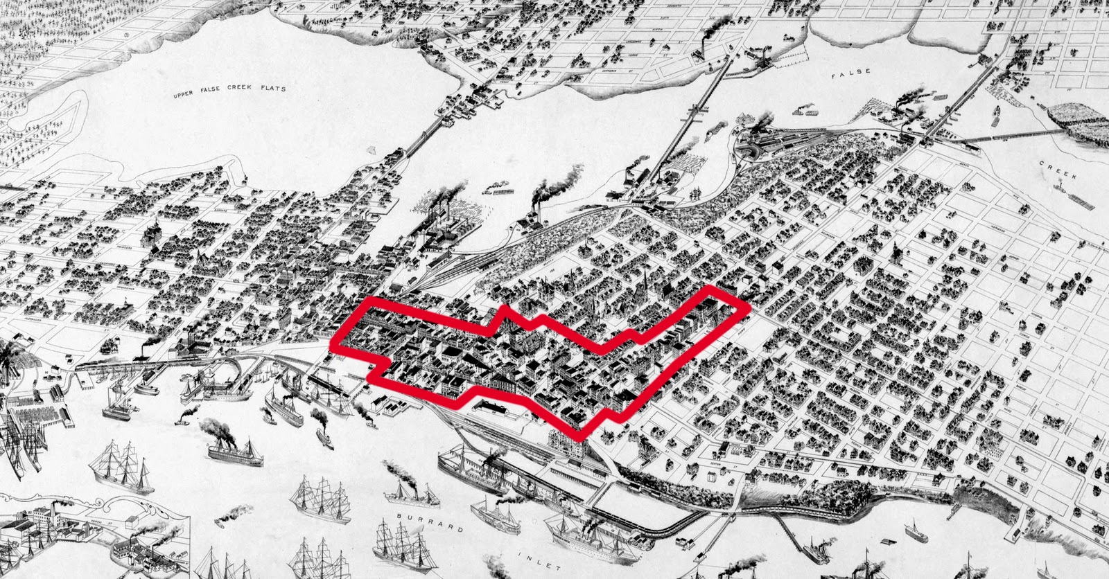
As a starting point, consider this 1898 view of Vancouver, drawn some years after the arrival of the Canadian Pacific Railway that kicked off an accelerating urban expansion.  The city population was only around 26,000 at this point, only slightly greater than nearby Victoria.  The commercial heart of the still-unzoned city is outlined in red, and occupies somewhere around 10 to 15 percent of the intensively built urban area:


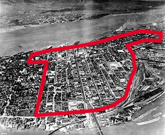
In the decades following the drawing of this city view, Vancouver's population exploded, topping 100,000 by 1911 and reaching 246,000 in 1931.  Notably, in 1927, Vancouver adopted its first Euclidean zoning ordinance, which for the first time designated the single-family residential districts that today cover over 70 percent of the city proper.  A 1930s-era aerial view of the downtown (the opposite direction from the previous image) shows what had happened to the central commercial district in the intervening 30 years, again, with the commercial areas outlined in red:

The area containing most commercial activity has expanded by about 6.5 times since 1898 as compared to a population growth of 9.5 times (the industrial areas have grown at a far more rapid rate).  There are virtually no high-rise buildings at this point, although the technology to build them had been in existence for at least 30 years.  That large commercial buildings had replaced many hundreds of earlier freestanding residential homes is evident by comparing the two images.  The pattern of growth is that of a horizontal expansion of a mid-rise urban fabric punctuated by the occasional taller building, rather than a vertical concentration of space near the waterfront. 

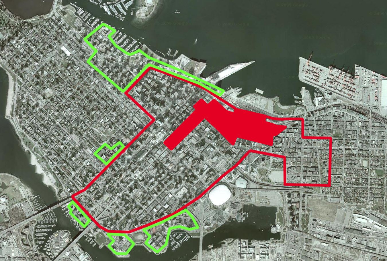
Eighty years later, the population of the city had more than doubled to 640,000 in a metro area of 2.3 million, representing a metro area increase of 7.8 times, yet the downtown office area had increased by only 1.3 times since the early 1930s.  The contemporaneous aerial image below shows the progression from 1898 to 1930 to the present day, with the solid red area representing the 1898 downtown, the outlined red area the 1930 downtown, based on a 1930 zoning map, while the green outline shows expansions of the business district since then, based on a current zoning map and the aerial view:


Vancouver's zoning map confirms this, showing the downtown district as the small purplish-shaded area in the middle of the top half of the map (a separate height-limited zone covers Eastside, an area that was nearly demolished for highway construction in the 1960s).  A handful of retail subcenters to the south, marked in red, contribute some additional land, although their zone's description states an intent to "limit[] the amount of office space."  A vast trainyard, zoned industrial (light blue), blocks expansion to the east; the West End, zoned residential, blocks it to the west, with more residential to the south, although with some limited potential for expansion in the False Creek area:


And just how flexible has the zoning code been to changing needs over the last 80 years?   Compare the above to the 1930 plan drawn up by prolific American planning consultant Harland Bartholomew, who was bluntly given his task by city leaders for whom the moral virtues of the single-family detached home needed no explanation (p. 60: "When Bartholomew asked what abuses he should consider in the interim zoning by-law of 1927 he was preparing, the chairman replied that 'the only serious abuse . . . is the intrusion of undesirable apartment houses into residential districts'"):


If the two maps are compared closely, it is possible to see how, overall, there has been virtually no change in the important boundaries.  The combined office/industrial area is nearly identical in both 1930 and in the present map.  At most, commercial and residential uses have succeeded small areas of industry in the downtown and parts south (Bartholomew's most obvious miscalulation -- the presence of excessive amounts of waterfront industrial separating homes from the business district -- was actually the plan's greatest asset, as it inadvertently would permit this limited succession of uses).  The single-family areas remain well "protected" against the encroachment of higher value uses in line with the intent of the 1920s planners.

 Deprived of space for horizontal expansion, the story of Vancouver's office districts since the 1950s, when construction resumed after a 20-year hiatus, is one of leapfrogging edge cities and debates over height limits.  Having spread its population across the entire Burrard Peninsula in detached homes ever since the arrival of the streetcars in the 1890s, Vancouver had little land remaining within the city boundaries for large new commercial subcenters, except that now a residential straitjacket held the downtown within strict boundaries.  Residential NIMBY-ism, as acute in Vancouver as in any American city, fought tooth and nail against even modest efforts at residential densification, much less expansion of the growing office sector.  The pressure cooker shakes and rattles:
"Vancouver’s rapidly accelerating growth and limited building space is forcing planners, builders and community groups to reexamine current height restrictions.  Vancouver’s old height restrictions capped downtown buildings at 450 feet, but under new regulations those guidelines have been relaxed up to 650 feet."   10/27/2007
More controversially, the city earlier this year floated plans to relax height limits in the Eastside area, one of the few remaining large-scale area of the 1920s-era downtown that has not been eradicated by high-rises.  The proposed change has drawn very reasonable criticism from several quarters (see here and here), yet none that address the fundamental problem: that there is nowhere near enough land available to business uses in Vancouver. 

Moreover, the zoning-driven shortage of homes has for some time been increasing demand for high-rise residential towers in the downtown, one of the few places such dense "infill" can be built.  With much commercial space having taken flight to the edge cities of Burnaby, Richmond and Surrey, it appears the undersupplied residential may even be capable of outbidding undersupplied commercial  in Vancouver's downtown.  The long term implications of this trend for the city are apparently of concern to Vancouver's city government. 

Now one can certainly make a case that high rises and edge cities might have multiplied in Vancouver regardless of zoning constraints -- the emergence of a large subsidiary center in Burnaby during an auto era seems predictable given the area's freeway configuration -- but as we see in other cities of the world, where zoning imposes few use-based constraints, mid-rise construction proliferates, with only a handful of scattered towers (Latin American and Japanese cities afford numerous examples).  Ed Glaeser has written frequently on the effect of zoning on housing costs while extolling skyscrapers -- perhaps a new study could shed light on the link between all three.

Please note, again, that this post is not intended as a specific critique of Vancouver, as the analysis is probably applicable to dozens or hundreds of other cities in North America which fell into zoning's grasp in the 1920s.  The city is arguably one of the best-run of its size, having avoided many of the poor decisions made by American cities.  The generally applicable nature of the observations here is the important thing.

Vancouver's own planners hesitant to endorse tall buildings: Vancouver planner Larry Beasley last year praised Washington DC's Height Act, and is critical of the idea that height is necessary for economic vitality

Further reading: Zoning and the single-family landscape: large new houses and neighbourhood change in Vancouver (discussing Vancouver's zoning history generally and the city's extraordinary micromanagement of residential zoning in particular).

Nice historic photos of the city over time: http://aaronwolf.blogspot.com/2011/08/vancouver-over-100-years-of-photographs.html

Thursday, September 15, 2011

The Densest (Urban) Environment in the World


"Central Park" on the ship.

No, not the Upper East Side, nor Hong Kong, nor even Dharavi, but the new cruise ship Allure of the Seas.  At 1187 feet long, and having capacity for nearly 9,000 passengers and crew members, the population density of the ship, when at capacity, can effectively exceed 1.2 million per square mile.  This is well in excess of Dharavi's 800,000.*

Lest one think the urban comparison is overstated, the urban qualities of the ship, easily visible in its design, are emphasized in its promotional materials:


"Longer than New York City's famed Chrysler building, the Allure of the Seas is so big, that it has "neighborhoods" like Central Park, Royal Promenade and Boardwalk. Like a city at sea, each "neighborhood" has its own unique "personality" along with numerous attractions that everyone onboard can enjoy..."
The New York Times noted the same quality:


"After we ate at the Chops Grille the next night, with its Chicago stockyards theme, and another day at Sorrento’s pizzeria, with photos of Manhattan, I began to see that the Allure is an urban ship, a celebration of cities, a 24-hour dream of lights and movement and the power of being in the center."
The cruise ship arguably represents the ultimate glorification of the public realm at the expense of the private, with living quarters, for most passengers, cramped in comparison to those of the cheapest hotel lodgings on land.  It is also the ultimate pedestrian-centric environment, reliant entirely on foot transportation.  And yet, the ship is a highly desirable "getaway" for Americans from across the country. 

In spite of these typically urban, and traditionalist urban, qualities, the architect best known for deriving inspiration from the design of large passenger vessels is none other than Le Corbusier, who was attracted by the streamlined nautical aesthetic of ships as well as their implications for urbanism.  The Unité d'Habitation was itself conceived in part as a self-contained, permanently-anchored ocean liner equipped with both necessities and amenities, thus taking the lesson of the big ship quite literally -- perhaps too literally.  The Unité mimicked the ocean liner's isolation even when there was no need to do so, and shrunk units even in the absence of spatial constraints. 

Are there other, more pro-urban, lessons to be learned from the "high density design and rigorous servicing discipline" of ships, as Stewart Brand asked in How Buildings Learn?  I'll leave that one hanging.

*The since-demolished Kowloon Walled City was reported to have had over 3,000,000 per square mile in the late 1980s – essentially representing four Dharavis stacked on top of one another.

Monday, September 12, 2011

Skyscrapers: Cause and Effect

Last week, Planetizen ran an excellent piece on the role of skyscrapers in today's cities, contrasting the arguments of James Howard Kunstler and Ed Glaeser along with commentary from the engineers and architects responsible for designing and tall buildings and their infrastructure.  It examines arguments based on comparative energy use, maintenance and refurbishment and on the effect on urbanism and city life, ultimately concluding that whether skyscrapers are appropriate in a particular case is a complex question that will turn on a variety of contextual factors.

This is a topic that I've discussed before, here, here and here.  But I'd raise one more question: is it really possible to separate a discussion on the role of the skyscraper from the land use patterns and zoning constraints of the typical North American city?

Leon Krier has an illustration on this point in The Architecture of Community, where he depicts a recognizably American city of a handful of skyscrapers surrounded by a vast sea of detached single family homes next to his preferred model of the polycentric city with multiple nodes, none obviously larger in scale or importance to one another, under which he observes:

"Exactly like an individual who has reached maturity, a 'mature' city cannot grow bigger or spread out (vertically or horizontally) without losing its essential quality. Just like a family of individuals, a city can grow only by reproduction and multiplication, that is, by becoming polycentric and polynuclear."
The North American skyscraper, arguably, is only a symptom of the failure of cities to adhere to this growth model, a model that is inherently dense and mixed-used to enable the provision of convenient urban services and amenities to each quarter. 

Consider one of the best examples of the North American type: Vancouver, which avoided the construction of downtown freeways, and which has a large and efficient mass transit network.  As can easily be seen from an aerial map, Vancouver is a monocentric city, with commercial high-rises heavily concentrated in the downtown area outlined in red, representing just over 1% of the greater metro area:

The Vancouver city government confirms this, noting that over two-thirds of all city jobs (and 22 percent of regional jobs) are located in the immediate downtown area.  In the same document, the city tries to allay fears that jobs are "moving out to the suburbs," even to the extent of touting zoning exclusively for commercial use (i.e., subsidizing office space).  Unsurprisingly, the city notes that 102,800 commute in to the central business district each day, while 16,400 commute out.  The transit system itself reflects this monocentric arrangement, as all lines of the SkyTrain converge on the small downtown.  Outside the downtown, suburban-style single-family detached housing predominates, occupying the vast majority of city area -- perhaps in excess of 90%.

With this sort of development pattern, is it possible not to have a dense core of skyscrapers, regardless of what one may think of them?  When residential areas are 1) low density and 2) zone out commercial and industrial over large areas, the remaining office areas, confined to the original central business district by an ever-expanding belt of homes, have nowhere to go but up.  The exception, Washington D.C., its height constrained by law and its building footprints hemmed in by streets of excessive width, compensates by spreading its downtown horizontally and further outwards to several centers beyond its jurisdictional boundaries.

The mass transit system, in response to this arrangement, bends all lines toward the core, yet this only worsens the imbalance by further raising property values at the center.  At last, we arrive at the familiar arrangement of 500-foot office buildings surrounded by mile upon mile of low-density homes, until the bursting commercial downtown leapfrogs out to an edge city on the residential fringe, leading to hand-wringing in the city council about the "decline" of the downtown.  (Tyson's Corner lookalike Richmond, along with Burnaby, seem to fulfill that function in Vancouver, being as commercial-heavy, but even more auto-centric, than the downtown).  Can the skyscraper really be blamed for this state of affairs? 

On the other hand, an urbanism on the model Krier proposes, which exists in countless cities outside North America, including those of the United States' own southern neighbor, has no economic need for skyscrapers, and sprouts only a few, those driven by corporate status-seeking rather than necessity.  The issue becomes nearly moot, and height limits, where they are implemented, less contentious. 

A Vancouver built to a Parisian level of density, and imitating Paris' lack of Euclidean zoning, would occupy the area shown below -- barely 10% of the existing regional metro area, with no high-rises, and with the same population.  The key difference, though, being that while today's Vancouver (and dozens or hundreds of cities like it) is built out with a giant and immovable low-density residential buffer, forcing the city to shunt its residential growth into towers in the already overburdened downtown, or to engage in a difficult process of upzoning low density residential, in this model, the city has abundant room for growth within its own borders by "reproduction and multiplication." 


Wednesday, September 7, 2011

Coding Emergence

I've been reading about the work of Swiss programmer and 3D artist Pascal Mueller, who has for the last several years been developing and refining a computer program capable of generating cities of realistic form and complexity.  As the paper introducing the program describes:

"Modeling and visualization of man-made systems such as large cities is a great challenge for computer graphics. Cities are systems of high functional and visual complexity. They reflect the historical, cultural, economic and social changes over time in every aspect in which they are seen. Examining pictures of a large-scale city such as New York reveals a fantastic diversity of street patterns, buildings, forms and textures. The modeling and visualization of large-area cities using computers has become feasible with the large memory, processing and graphics power of today's hardware.

We present a system called CityEngine which is capable of modeling a complete city using a comparatively small set of statistical
and geographical input data and is highly controllable by the user."
The potential applications for a procedural creation range from research and educational purposes such as urban planning and creation of virtual environments to simulation.  Especially the entertainment market such as the movie and game industry have a high demand for the quick creation of complex environments in their applications. ...

The results of one such modeling exercise are shown at right, where a Pompeii lookalike was generated using a few basic inputs -- essentially, a form-based code with architectural guidelines -- derived from study of the archaeological site.

Most interesting to me is CityEngine's process for creating street networks, which Mueller divides into four separate categories: the "basic," or organic, street network, the grid, the radial pattern, and a pattern designed to let streets follow the route of least elevation on hilly terrain (p. 304).  From the point of view of the programmer, the organic network is simultaneously the simplest and the most complex of the patterns:

"This [the "basic"] is the simplest possible rule. There is no superimposed pattern and all roads follow population density. This may also be referred to as the natural growth of a transportation network. Mainly older parts of cities show such patterns. All other rules are based on restrictions of this rule by narrowing the choices of branch angles and road segment length."

The program therefore provides a glimpse at a possible way to mathematically recreate, or at least imitate, the process of organic street growth.  Missing from this initial model is the element of time, and a way to show the evolution of a network, but this is something Mueller has since worked on heavily, as can be seen at this link.  The paper describing the methodology is here.  Remarkably, this appears to be one of the first attempts to realistically model the process of incremental, emergent urban growth by computer simulation (and no, SimCity does not quite count).  To read more, Mueller has most of his articles linked on his website -- this is definitely a work in progress and something to follow.

Friday, September 2, 2011

Friday Read: Zoning, Here and in France

 law journal article on the economic and environmental problems inherent in Euclidean zoning, always beneficial to read even if one is familiar with the arguments, but especially nice for launching a critique simultaneously from all ideological angles, leaving a little something for Randal O'Toole, Ed Glaeser and David Owen to each nod in agreement with:
"Euclidean zoning distorts the real estate market in so many ways that it manages to simultaneously conflict with conservative, libertarian, and liberal values. In addition to increasing the average price of housing, “[t]he fact that a zoning map allows high density housing in some areas, only single family housing in others, only industrial and commercial use in designated locations, and high rise office buildings in downtown areas, creates great disparity in value among a city’s many properties.” While “[a] local regulation imposing a maximum land value would almost certainly be viewed as a [Fifth Amendment] taking, . . . zoning laws that effectively impose a maximum land value have been upheld. . . .”

And because municipal zoning authorities, rather than the market, dictate what housing types will be available and favor single-family homes, “profitable sites for [multifamily housing] are artificially scarce” and thus artificially expensive. Such a situation is clearly incompatible with free-market principles, and since affordable housing often means some type of multi-family housing, it is also hostile to the goal of increasing the access of lower-income families to affordable housing. In addition, Euclidean zoning increases the burden on middle-class families: while the artificial scarcity of multi-family sites might be expected to reduce the cost of single-family homes by increasing the availability of single-family sites, this possibility is nullified by the tendency of suburban municipalities to require large minimum lot and house sizes. That “forces people to consume land and improvements they do not want,” at a higher cost than they would pay were they allowed to buy only the amount of property they want. “This forced consumption is inefficient because the recipient could sell the extra land and improvements on the market for more than what they are worth to the recipient. . . .”
As a bonus, it contains an in-depth comparative look at French and American (specifically, New York and Parisian) approaches to land use and zoning:

"[T]he most recent Paris zoning code divides the city and surrounding greenspace into just four zones, three of which are neither residential nor commercial (those three are Zone N (Nature and Forests); Zone UV (Green Urban), i.e. parks and other public landscaped areas; Zone UGSU (Major Urban Services), i.e. train stations and rail lines, hospitals, waste treatment centers, water reservoirs, riverside ports, convention centers, and major centers of industrial distribution); the city’s houses, apartment buildings, shops, cafés, offices, and other commercial establishments thus fall within a single zone, General Urban."
* * *

As for the relative absence of unsightly buildings, this is at least in part due to the fact that Paris has historically tended to zone for structures rather than uses. Between 1607 and 1902, zoning was used to set maximum building heights, to regulate building materials due to fire risk, and to impose minimum courtyard sizes to promote access to sunlight and free circulation of air. This has continued to the present day, with Paris’s General Urban district subdivided not into use zones but into areas of different maximum heights and structure types."

This is a true comparative look at property rights, much unlike the International Property Rights Index I mentioned earlier this week, and delves into the crucial details that, when applied in the aggregate, have enormous consequences for the resultant urban form.

Thursday, September 1, 2011

Last Look At Seaside

After reading Bruce Richards' comment on the previous Seaside post,  I returned to the town on my last day in Florida and took a closer look at some of the "Krier lanes," the narrow footpaths running behind and between the houses of Seaside which apparently double as utility easements.  Only by walking these paths can one appreciate some of the more subtle design decisions made by the town planners.

What I found interesting to note is not only the frequency of accessory houses, but the presence of four lots (in the center of the image at right, although there are several others in the town) of typical Seaside dimensions of 50'x100' which have each been subdivided into two 50'x50' lots, a size very close to that which Nathan Lewis has suggested for a dense neighborhood of single-family detached homes. 

The only access to these lots, as with the accessory houses, is by the lanes.  Despite the small size of the lots, the houses are quite ample:

The house to the left in the top photo is, I believe, this one, a 1,400 square foot house with 550 square feet of porch space.  The address is given as Savannah Street, one of the wide, brick-paved streets, yet the only direct access is by the paths. 

A city of residential lots of this average size, using a distance between houses the same as that in the lower photo (about 16') for rights-of-way, and with short and narrow blocks of 300'x100', would attain a density of over 9,100 units/square mile, or, using the American average of 2.59 persons per household, around 24,000 people per square mile.  A few wider streets would be needed at intervals, but they should not alter this outcome greatly.  A real life example is Nathan Lewis' own Tokyo suburb of Seijo, which he's used to familiarize us with the neglected area of Japanese urbanism:


The Seijo street view, with a remarkably Seaside-like house on the left:


Or, at right, consider an entire neighborhood built along these lines.  This is a development at the fringes of Tokyo -- just a bit further west steep mountains quickly rise up.  It also happens to be about 70 acres, very close to Seaside's 80.  Even the street network is vaguely similar, yet density is about 25% higher.  It's not necessarily a model to be copied, but it does show what could be accomplished using the basic 50'x50' lot that Seaside pioneered along with 16' streets.  To densify further, while retaining a single-family detached form, subtract half or so of the 50'x50' lots and replace them with the "accessory dwellings" that are abundant at Seaside, and which, under separate ownership, can fit on their own 20'x25' lots:


These cottages offer around 500-800 square feet, not much different from the "micro homes" currently being built in Portland that commenter Vince has mentioned. 

The promise offered by these common sense innovations at Seaside unfortunately has not carried over into most New Urbanist developments.  At Kentlands, for instance, although many individual houses can fit within a 50'x50' lot, a rear yard of equal size has typically been reserved for a detached garage, an issue I've talked about before.  But the lessons of Seaside are there for anyone willing to look a little closer at the remarkable planning that went into it.

For more on these issues, I strongly recommend reading Nathan Lewis' site if you haven't discovered it already:


Yours truly enjoying a beverage and a good book in Seaside
after a day exploring the town.